
Relevant for Exams
Wildfire rages for third day in Dzukou Valley, aerial operations planned due to difficult terrain.
Summary
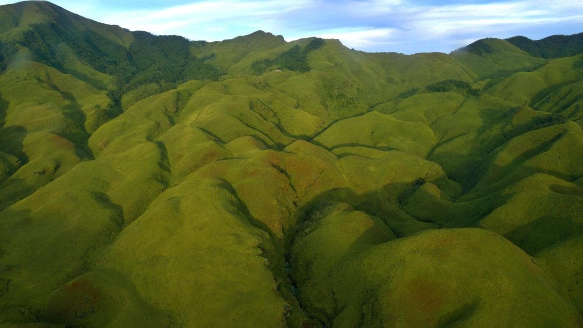
A wildfire has been raging in the famed Dzukou Valley, located on the border of Nagaland and Manipur, for the third consecutive day. Aerial operations are being planned to combat the blaze, as initial drone appraisals were hindered by the difficult terrain. This event is significant for competitive exams due to its environmental impact on a sensitive biodiversity region and its geographical location.
Key Points
- 1A wildfire has been active in the famed Dzukou Valley for the third consecutive day.
- 2Dzukou Valley is a significant ecological and tourist destination situated on the border of Nagaland and Manipur.
- 3Aerial operations are likely to be conducted to control the blaze, given the challenging conditions.
- 4Drone appraisal for assessing the fire's extent could not be undertaken due to the valley's difficult terrain.
- 5The Dzukou Valley is renowned for its natural beauty and rich biodiversity, making the wildfire an environmental concern.
In-Depth Analysis
The Dzukou Valley, a breathtaking landscape nestled at the border of Nagaland and Manipur, recently became the focal point of an environmental crisis as a devastating wildfire raged for several days. This incident not only highlighted the fragility of India's rich biodiversity but also brought to the forefront the challenges in disaster management, particularly in remote and ecologically sensitive regions. Understanding this event requires delving into its geographical, ecological, and governance dimensions.
**Background Context and What Happened:**
Dzukou Valley, often referred to as the 'Valley of Flowers of the North-East', is renowned for its pristine natural beauty, rolling hills, and unique flora, most notably the Dzukou Lily. It is an integral part of the Indo-Burma biodiversity hotspot, one of the world's most critical and threatened biodiversity regions. The valley's terrain is characterized by high altitudes, dense bamboo thickets, and grasslands, making it susceptible to fires, especially during dry winter months. The wildfire, which began around December 29, 2020, rapidly spread, consuming vast tracts of vegetation. Initial efforts to assess the fire's extent using drones were hampered by the difficult, mountainous terrain and dense smoke, necessitating the deployment of more robust aerial operations. This incident underscores the recurrent threat of wildfires in India's forest ecosystems, often exacerbated by prolonged dry spells and human activities.
**Key Stakeholders Involved:**
Combating a disaster of this magnitude requires multi-agency coordination. The primary stakeholders included the **State Governments of Nagaland and Manipur**, whose Forest Departments and State Disaster Management Authorities (SDMAs) were on the front lines, mobilizing ground teams and local volunteers. The **Central Government** played a crucial supportive role, with the Ministry of Home Affairs (MHA) coordinating assistance. The **Indian Air Force (IAF)** was instrumental in conducting aerial surveys and carrying out Bambi Bucket operations to douse the flames, demonstrating the critical role of defense forces in national disaster response. The **National Disaster Response Force (NDRF)** and **State Disaster Response Forces (SDRFs)** were deployed for ground operations. Local communities, often the first responders, also played a vital role in fire fighting and providing local knowledge. Environmental organizations and NGOs also raise awareness and advocate for long-term conservation strategies.
**Why This Matters for India:**
The Dzukou Valley wildfire holds significant implications for India across several fronts. Environmentally, the loss of biodiversity, including endemic species, is irreparable. Forest fires contribute to significant carbon emissions, exacerbating climate change, and destroy critical wildlife habitats, leading to potential human-wildlife conflicts. Economically, the valley is a growing ecotourism destination; such incidents can severely impact local livelihoods dependent on tourism and forest resources. Socially, the smoke and air pollution affect the health of nearby communities. From a governance perspective, the incident highlighted the need for improved inter-state coordination in disaster management, especially for areas straddling state boundaries. It also underscored the necessity for advanced technology and robust infrastructure for early detection and rapid response in remote areas.
**Historical Context and Future Implications:**
Wildfires are not new to India. Regions like the Western Ghats, Uttarakhand, and parts of the Northeast frequently experience forest fires, often linked to dry deciduous forests, jhum cultivation practices, and human negligence. The India State of Forest Report (ISFR) consistently highlights the vulnerability of Indian forests to fires. The Dzukou incident serves as a stark reminder of the increasing frequency and intensity of extreme weather events due to climate change, including prolonged dry spells that create perfect conditions for such blazes. In the future, there is a critical need for proactive measures: investing in satellite-based early warning systems, enhancing forest fire prevention strategies (like fire lines, controlled burning), strengthening community participation in forest protection, and improving the capacity of disaster response forces with specialized equipment and training for difficult terrains. Sustainable tourism practices and stricter regulations against activities that could cause fires are also paramount.
**Related Constitutional Articles, Acts, or Policies:**
This event is deeply linked to India's environmental and disaster management framework. **Article 48A** of the Directive Principles of State Policy mandates the State to 'endeavour to protect and improve the environment and to safeguard the forests and wildlife of the country.' Correspondingly, **Article 51A(g)**, a Fundamental Duty, enjoins every citizen 'to protect and improve the natural environment including forests, lakes, rivers and wildlife, and to have compassion for living creatures.' Key legislation includes the **Environment (Protection) Act, 1986**, which provides a broad framework for environmental protection, and the **Forest (Conservation) Act, 1980**, which regulates the diversion of forest land for non-forest purposes. The **Wildlife (Protection) Act, 1972**, protects the flora and fauna of such regions. For disaster response, the **Disaster Management Act, 2005**, provides the legal and institutional framework for disaster management in India, leading to the establishment of the NDRF and SDMAs. The **National Forest Policy, 1988**, also emphasizes the maintenance of environmental stability through preservation and restoration of ecological balance. These legal and policy instruments underscore India's commitment to environmental protection and disaster preparedness, which are tested during events like the Dzukou Valley wildfire.
Exam Tips
This topic falls under GS Paper I (Geography - Physical Geography, Indian Geography) and GS Paper III (Environment & Ecology, Disaster Management) for UPSC. For SSC and State PSCs, it's relevant for General Awareness, Geography, and Environment sections.
Study the geographical location (Nagaland-Manipur border), specific flora/fauna (Dzukou Lily) and its status as a biodiversity hotspot (Indo-Burma Hotspot). Also, understand the causes and types of forest fires in India, their environmental impact, and prevention methods.
Common question patterns include: MCQs on the location of Dzukou Valley, its ecological significance, constitutional provisions related to environmental protection (Articles 48A, 51A(g)), and the roles of various disaster management agencies (NDRF, SDRF, IAF). Mains questions could focus on challenges in disaster management in difficult terrains, the impact of wildfires on biodiversity and climate change, or the role of community participation in forest conservation.
Related Topics to Study
Full Article
Sources said the aerial assessment was carried out after a drone appraisal could not be undertaken due to the difficult terrain